The Passes

I'll admit it right here, right now:  Durango cyclists have an (unfair?) advantage for a number of reasons, but the one I really like is the proximity to the million dollar highway, US Hwy 550 between Durango Mountain Resort and Ouray.  The road strikes fear into those driving trucks, RVs, or anyone pulling trailers.  Anyone from Iowa for that matter ;)  The route hits 3 major passes:  Coal Bank, Molas, and Red Mountain.  They are all between 10,600 and 11,000'.

Since the elevation is so high, power output is much reduced.  According to one performance model (http://www.midweekclub.com/powerFAQ.htm#Q17), at 11,000' you have between 77% and 81% of your sea level threshold power and not a watt more.  Some think this is bad for training - half of the reasoning of the live high/train low model is based on such reasoning.  But I say bull hockey.  Guys that train at elevation in these parts kick some serious booty.  Ned is  one of them, training high hasn't hurt his palmares!  One thing I've noticed when training at elevation is that recovery is faster than a similar TSS workout at lower elevations.  In the latter, FT is higher so absolute work performed is much higher - and I presume that accounts for more muscle damage (don't quote me on that though, I'm no physiologist).  Of course I mix it up, interjecting high intensity stuff at (relatively) lower elevations mid-week.  It's my opinion though, that prolonged work at elevation builds FT power because it's all relative - FT relative to available Os.  At elevation I can do a helluva lot more "threshold" work than lower elevations. 

In any case, after a serious block of elevation work last year I saw gains beyond expecations, so I'm at it again.  Today's ride was 111 miles, Durango to Red Mtn pass and back.  Total ride time was about 6:20.  Not sure how much climbing, but by Silverton there is over 5,000' and that was just the first 2:40, only 2 of 5 passes climbed...

The aesthetic perks are huge.  It's awesome country any time of year up there...right now it's mud season at the lower elevations, and still winter at higher elevations.

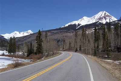
This shot is just before the base of Coal Bank Pass.  Engineer Mountain on the right.

The top of Red Mountain pass is still wintry.  Last year snowpack was more than double this amount. 

6 years ago I spent a summer guiding rafts down the upper Animas river.  This is the first view the crews get, looking down the daunting Animas River gorge from Silverton.

Now you know another reason you should groan when a Durango cyclist shows up to your next event!

Published Sunday, April 16, 2006 5:30 PM by Dave
Filed Under:

Comments

# @ Monday, April 17, 2006 1:45 PM

Hey Dave,

I just saw that you commented on my blog! Actually, right when I got back into town I tried contacting you, but I wasn't able too. I just road the passes, as well. I didn't go as far as you, but it was nice to get up there and play!

walker t

# @ Monday, April 17, 2006 7:35 PM

Got out to Durango to ride about 5 years ago. What a place! You are indeed lucky. I've been to a few other place in CO (CB 3 times) but Durango seems like a place where you could actually ride more than 3 months a year and have a real job too.

Later,

JM

Jason

# @ Tuesday, April 18, 2006 5:45 PM

So...Do you mind me asking, when you do these big high-altitude rides, are you riding with wattage goals, HR zones, or just riding?

Just curious.

- Rich

Rich Abbott

# @ Tuesday, April 18, 2006 6:16 PM

oooh luvley pics. Makes me want to pedal up them roads.

Lynda

# @ Tuesday, April 18, 2006 7:32 PM

Rich - don't mind at all. Each passes ride is a bit different, it really depends on the length of the ride. But the goal for each of them is usually to maintain the highest power that I can sustain for the duration of the ride. I pace them all by PE as it is a much more useful real-time tool in this case than power.

Invariably the last pass is done at lower IF than the first...ticks me off too! But to put some numbers on it, Sunday's ride was done at an IF between .9 and .93 on each pass where the climbs vary from 15 to 45 minutes. IF for the entire ride was .83. There's certainly some fudge room in those values due to the variation of FT at altitude...

Do you have high altitude climbs in your area?

Dave

# @ Wednesday, April 19, 2006 4:38 AM

My lungs would implode out there. Just kidding!
Looks super sweet to ride in and around. I'll just stick to my 25 mph head and cross winds.

Jeff Kerkove

# @ Wednesday, April 19, 2006 6:26 AM

I live in Salt Lake, and this time of the year we are pretty short on high-altitude climbs. The climbs around my house are only about 6000' in altitude. The climbs to the resorts typically top out at about 8500'. I think the others are mostly un-plowed. After the snow melts, there is a lot of climbing in the 8-10k' range, especially off-road.

Rich Abbott

# @ Sunday, April 23, 2006 4:53 PM

Hey Dave - it might be that your lower elevation work here in Phoenix is screwed up because all of the polution. Sure, you're getting more oxygen to your muscles, but they're having process out all that garbage too. A friend of mine was out here for a week last Nov/Dec and developed asthma shortly after leaving... go figure.

I was thinking of these pictures yesterday when I was climbing Mount Ord. Not as epic looking as these climbs, but it was cool slowly realizing that you've climbed above all of the neighboring peaks and still had 500' more to go.

Travis Swicegood